ZeD-MAP: Bundle Adjustment Guided Zero-Shot Depth Maps for Real-Time Aerial Imaging
arXiv cs.RO / 4/7/2026
💬 OpinionIdeas & Deep AnalysisModels & Research
Key Points
- ZeD-MAP addresses real-time depth reconstruction for ultra-high-resolution UAV imagery by combining zero-shot diffusion depth predictions with a bundle-adjustment (BA) guided mapping pipeline.
- The method groups streamed frames into overlapping clusters and runs incremental, cluster-level BA to produce metrically consistent poses and sparse 3D tie-points.
- BA-derived tie-points are reprojected into selected frames to provide metric guidance for diffusion-based depth estimation, improving temporal/metric consistency compared with diffusion-only probabilistic inference.
- Experiments on ground-marker UAV flights using the DLR MACS system show sub-meter accuracy (≈0.87 m XY error and ≈0.12 m Z error) while keeping per-image runtimes in the ~1.47–4.91 s range.
- The authors argue that BA-based metric guidance yields consistency comparable to classical photogrammetry but with significantly faster processing for real-time 3D map generation, noting minor noise from manual annotations.
Related Articles

Human-Aligned Decision Transformers for satellite anomaly response operations with ethical auditability baked in
Dev.to
That Smoking-Gun Video? It's Not Evidence. It's a Suspect.
Dev.to

AI Citation Registries and Website-Based Publishing Constraints
Dev.to
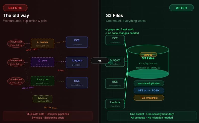
Amazon S3 Files: The End of the Object vs. File War (And Why It Matters in the AI Agent Era)
Dev.to

大模型价格战2025:谁在烧钱谁在赚?深度解析AI成本暴跌背后的生死博弈
Dev.to